Map:
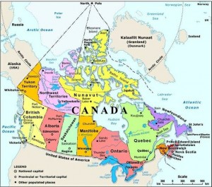
The Region on the left side of the map, which shows the Western part of Canada ist he Cordillera Region. British Columbia and Yukon are the Provinces in that Physiographic region, in the East there is a little part of Alberta included. The Western and Northern extent are the Northern Corner of the Yukon, where the border to the USA is. The Eastern extent peeks into Alberta and the Southern extent ist he border to the USA.
Relative Location:
The Cordillera Region extents from Southern BC to Northern Yukon. It is 800 kilmeters wide and, going from the Pacific Coast in the West to peeking into Alberta in the East. The Southern extent ist he US border with the Ivvavik Park and ist Northern Extent.
Absolute Location:
Northern Extent: 69°32´59.5572´´N
Southern Extent: 48°4´41.0844´´N
Western Extent. 140°53´19.2192´´W
Eastern Extent: 113°54´22.5000´´W
Place and Region:
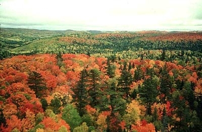
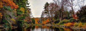
The Cordillera has a diverse , varying landscape composed by parallel mountain ranges, which are separated by plateaus, trenches and valleys. There are also dormont volcanoes and in the Northern part oft he region there are large glaciers and ice fields. The region also has a teeming with wildlife and vegetation, as its comprised of 6 different biomes, which are: Tundra, Coniferous Forest, Coast and Interior Forest, Parkland, Grassland and Open Woodland. Since both Coniferous and Coast and Interior Forest are forest biomes, there are a lot of evergreens (spruce, fir, spine, etc.) and large trees with greater groth due to wet and mild climate.
Stanley Park, Vancouver, BC
The cultural landscape is mostly located in the Coastal areas in Southern BC with Vancouver, the Tri Cities area and other cities and communities. Those cities are surrounded by mountains, which are the main part that shapes the physical landscape of of the Cordillera Region. On those mountains the cultural landscape is composed from skiing resorts and their towns, skiing lifts and roads.
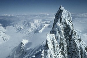
Mt. Waddington
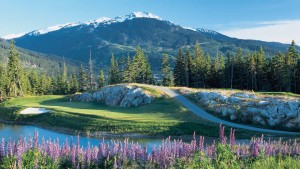
Golf Chateau, Whistler, BC
The other major part of the physical landscape are trees and green spaces in the grasslands and Ice fields in the Northern Yukon.
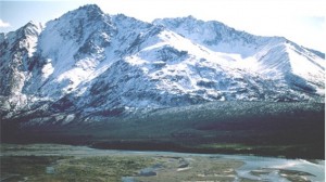
Wernecke Mountains, Yukon
Formation:
The region was formed by the shifting of the Pacific Plate, which is an oceanic plate and the North American Plate, which is a continental plate. They are moving towards each other so oceanic subduction occurs, which causes the less dense, lighter oceanic plate to subduct under the more dense, heavier continental plate. This process caused Mountains, Plateus, Valleys and Volcanoes to form out of volcanic rock.
In this picture there a visualzation of oceanic subduction, like it occurs on the Pacific Coast of the Cordillera Region.
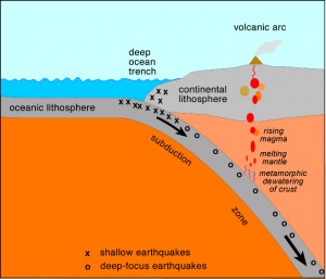
That is the reason why the coastal region in BC is mostly shaped by mountians. Erosion, caused by two factors, shaped the mountains to what they are now. First, in the last ice age, flowing glaciers carved the mountains under huge pressure and weight, and now rivers are still carving out valleys and moving minerals all over the region.
Human and Environmental Interaction
Natural Resources: The Cordillera Region has a variety of natural resources, with mining and forestry as the main industries. The rich, fertile soil maked agriculture another profitable industry in BC.
Economy in Numbers:
GDP
Total GDP: 204.805.000 Dollars
Real Estate: 36.365.000 (17.75%)
Construction: 16.767.000 (8.18%)
Health Care: 15.127.000 (7.38%)
Manufacturing: 14.693.000 (7.17%)
Public Administration: 12.736.000 (6.21%)
People Employed:
Total: 2.336.000
Retail and Wholesale: 348.000
Other Services: 305.000
Health Care: 275.000
Construction: 201.000
Educational Services: 189.000
Forestry: 54.000
Africulture: 21.000
The GDP and the numbers of employment are not necessarily dependent on each other, so for example there is an employment number of 189.000 in the Educational Services, this Industry is not in the Top 5 list of the industries with the highest GDP.
Map
Relative Location
The Interior Plains region extents from Western Alberta, where the border to BC is, to its Eastern extent in Western manitoba. It is very wide in the South, along the US border, but as we look more up North, it has only the West- East extent of Alberta. Ist Southern border is the United States border, the Northern border is the arctic sea in the Northwest Territories.
Absolute Location
Northern Extent: 69°57´37.5804´´N
Southern Extent: 48°57´56.8584´´N
Western Extent: 120°11´25.5480´´W
Eastern Extent: 97°7´8.9076´´W
Place and Region
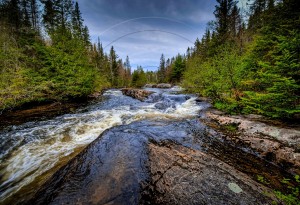
The landscape of the Interior Plains is mostly composed of flat lands, rolling hills and river valleys. The region is varying in biomes, with the Southern half composed of parklands, grasslands and coniferous forest, with the Northern half composed of open woodland.
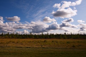
Alberta, Highway 63
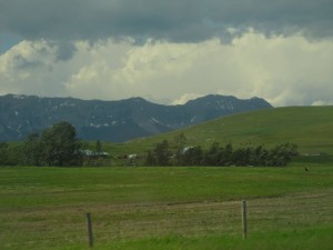
Porcupine Hills, Southwest of Calgary, Alberta
Formation
Soil, carried by the rivers from the Canadian Shield, formed this region as they settled as sedimentary rock in horizontal layers. That is why the land is mostly flat.
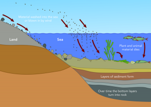
This picture shows how Sedimentary rock is formed.
Human and Environmental Interaction
Resources
The region has vast amounts of fossil fuels, making it have one oft he largest oil industries in Canada. The landscape, which flat and rich soil is also ideal for farming and agriculture. By digging huge holes into the ground and carrying soil away natural habitats are destroyed. In addition to that people have to build roads to get there, so they might have to cut down forests, which are important natural habitats.
Economy in Numbers (Alberta)
Employed: Total: 2.276.000
Top 5, Emplyoments by industry
- Trade (324.000)
- Health and Social Assistance (273.000)
- Construction (255.000)
- Professional scientific and technical services (175.000)
- Forestry, fishing, mining, oil and gas (155.000)
GDP: Total: 286.600.000
- Energy (80.248.000; 28%)
- Finance and Real Estate (40.124.000; 14%)
- Business and Commercial services (28.660.000; 10%)
- Construction (25.744.000; 9%)
- Retail and Wholesale (22.928.000; 8%)
Energy contributes most of GDP
- due to oil industry
- due to large deposits of fossil fuels
Map
Relative Location
The Canadian Shield surrounds the Hudson Bay, so it coverst he provinces Newfoundland, Quebec, Ontario, Manitoba and Nunavut. It extents from the southernmost of Ontario to all the way up north tot he south-east corner of Ellesmere Island in Nunavut. In width, the Canadian Shield goes from the Eastern part of Quebec to the Eastern part oft he Northwest Territories and the North- East corner of Alberta. Its southern neighbour are the St. Lawrence Lowlands and in the east it touches the Appalachian region and the Atlantic ocean.
Absolute Location
Northern Extent: 76°38´21.2136´´N
Southern Extent: 45°31´18.2784´´N
Western Extent: 83°9´59.4144´´W
Eastern Extent: 61°36´40.7807´´W
Place and Region
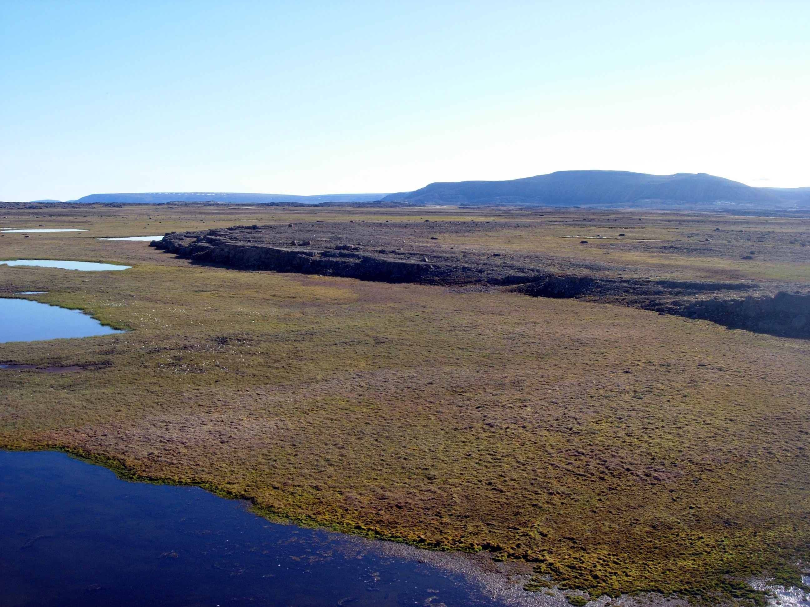
The Canadian Shield is a large area, making up half of Canada’s land surface. The region is mainly flat bare rocks, which makes it hard to build houses and nearly impossible to grow plants. The region is also composed of lakes and wetlands. This is due to the fact that the region was once a volcanic mountain range, that was worn down to its present state by the effects of glaciers (glacial erosion). The region is primarily coniferous in the Southern part, with small amount of mixed forests and open woodland. The northern part is primarily tundra with some subarctic areas.
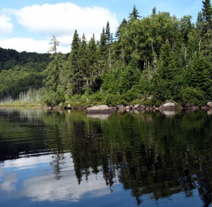
Picanoc River in Pontiac, Quebec with bare rock and surrounded by a coniferous forest.
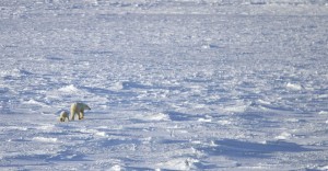
Tundra in Churchill, Manitoba just west of the Hudson Bay. Polar bears are one oft he few animal species that live in the northern biomes.
Human and Environmental Interaction
In this region there are many minerals to find, due to the region being covered by mostly bare
rock. The most common minerals are copper, coal iron along with gold and diamonds.
Numbers employed (Quebec)
Total: 4.097.000
- Health Care (576.500)
- Manufacturing (488.600)
- Wholesale, Retail and Trade (662.000)
- Professional, Technical and Scientific services (315.000)
- Accomodation and Food services (270.400)
GDP
Total: 370.064.000
- Manufacturing (5.439.940; 14,7%)
- Real Estate (4.181.723; 11,3%)
- Health Care (3.071.531; 8.3%)
- Public Administration (2.775.480; 7,5%)
- Construction (2.442.422; 6,6%)
Map
Relative Location
The St. Lawrence Lowlands region extents from southern extent of Ontario to the very edge of the Northwest of Newfoundland. In the west it goes from the western Manitoulin Island to the west coast of Newfoundland. At ist south is the US border which also surrounds the eastern and western area oft he southern most extent of the St. Lawrence Lowlands.
Absolute Location
Northern Extent: 49°33´13.4136´´N
Southern Extent: 41°46´16.7232´´N
Western Extent: 83°9´59.4144´´W
Eastern Extent: 61°36´40.7808´´W
Place and Region
The region has many fertile areas of of flat lands and rolling hills , leading to many fruits and vegetables to be grown. There are many trees as the region mainly consists of the mixed forest biome and traces of open woodland.

Lanaudier Plain, the picture show lots of rich soil which provides perfect conditions for farming.
Reserve Taunique de Portneuf, Quebec
Formation
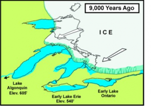
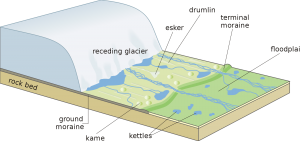
The land was carved and shaped by retreating ice sheets from the ice age. These sheets also pushed soils from the shield onto the land, which is why areas are so fertile. The lakes were made as the ice melted and filled the holes, that were pressed into the ground by the huge weight of the ice. That is why most of the lakes are not connected to any rivers or other lakes. They got their present state due to drainage.
Human and Environmental Ineraction
While not great in mineral resources the region has very rich and very fertile soils, leading to plenty of of farmlands.
Numbers employed (Ontario)
Total: 618.050.000
- Wholesale and Retail (1.042.000)
- Health Care (812.000)
- Manufacturing (244.000)
- Professional, Scientific and Technical services (529.000)
- Finance (543.000)
GDP
Total: 618.050.000
- Real Estate (84.591.000; 13,6%)
- Finance and Insurance (60.125.000; 9,7%)
- Professional and Administrative services (57.864.000; 9,3%)
- Public Administration (42.604.000; 6,8%)
- Health Care (41.702.000; 6,7%)
Map
Relative Location
The arctic region is the North- Eastern region on the map that is marked in yellow. In the Eastern Part, on Baffin Island there is the capital citiy of the province, Iqualit. The Arctic Region is composed of many small Islands around the Hudson Bay and ist Northern extents almost touch the West Coast of Greenland. The arctic region is in Northern Canada. Ist Western Border is the arctic ocean, the Eastern Border is Greenland. It is Northern from the Hudson Bay and the Canadian Shield region. The furthest Western extent reaches all the way to the Alaskan Border.
Absolute Location
Northern Extent: 82°59´38.8752´´N
Southern Extent: 63°38´33.2808´´N
Western Extent: 140°53´19.2192´´W
Eastern Extent: 68°38´33.2808´´W
Place and Region
The Arctic region is not as diverse and varying as for example the Cordillera region because it is too cold. The ground is permanently frozen, so plants can barely grow. The only plants that grow are mostly shrubs, which are outstandingly strong. Their strength results from the strong arctic winds. Those winds reach up to more than 200 kilometers per hour and nothing really blockst hem because it is mostly flat land.
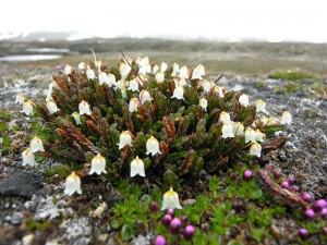
White Artic Bell Heather
The physical landscape is shaped by flatlands, plains and mountains and mostly icy, only for 2 to 3 months per year it is not covered in ice.
Iqualit, Nunavut, Canada
The only wild animals in the arctic regions are Polar Bear, Walruss and Narwhal. The reason why there is not a varying wildlife are the same factors that affect the vegetation: It is too cold and there is barely any food to find. The cultural landscape in the arctic is different from all the other Physiographic regions. There is a very little population density because it is hard to build houses and keep them warm in temperature of 40° C below and colder. The cities are composed of small houses and only little groups of houses.
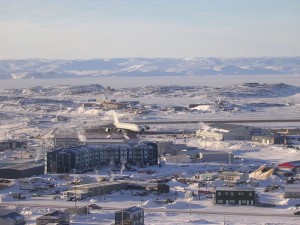
Iqualit, the capital of Nunavut, Canada
Formation
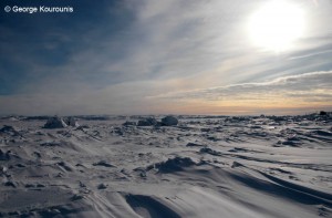
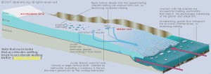
The arctic region was formed by flowing glaciers, which still cover 5% of the Canadian Arctic. Those Glaciers carved away rock and pressed the ground to a flat landsform. In the Winter a major part oft he arctic landsmass is formed by sea ice, so the area rapidly increases as the rivers, lakes and the ocean start freezing in September. In the South the waters are ice-free from June to October, in the North only from July to August.
This picture shows the glaciation that formed and shaped the arctic region.
Human and Environmental Interaction
The main natural resources oil and natural gas. Since the rock is the same as in the Appalachians, it is estimated that there are similar mineral resources. The industry is based on mining and oil.
(in million dollars, numbers from 2014)
- Final Consumption Expenditure (2010)
- Imports of goods and services (1944)
- Final Domestic Demand ( 3093)
- Goods (300)
- Business and Capital ( 831)
Map
Relative Location
The Appalachian region is the very Eastern region on this map. It covers the Eastern extent of Newfoundland and the provinces Nova Scotia, New Brunswick and Prince Edward Island. It has similar
Precipitation as the Cordillera region because it is a Coastal region, too.
Absolute Location
Northern Extent: 51°43´37.3008´´N
Southern Extent: 45°31´18.2784´´N
Western Extent: 74°10´46.8768´´W
Eastern Extent: 52°59´52.9692´´W
Place and Region
Appalachians are composed of highlands, mountains (mainly rolling hills), narrow river valleys and Fjords. The biomes are Open Woodland and Coniferous and Mixed Forest. In those mountains it is not as hard to settle as in the Rocky Mountains or the Coastal Mountains because the Appalachians are not as steep and not as high. But they do affect the Settlement and the economy, because there are not really big open spaces where people could farm food.
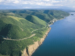
Cabot Trail on Breto Island in Nova Scotia
Formation
The region was formed oceanic subduction, since it is right next to the ocean. When the tectonic plates subduct they form volcanoes and mountains. Those mountains were eroded by glaciers, which gave them their present shape.
Human and Environmental Interaction
The main resource of the region are logging and coal mining. The logging started off as a big challenge because in the region there weren´t really good roads and the acces to the mining and logging places was very difficult.
People employed (Newfoundland)
Total: 236.200
- Forestry, Fishing ( 16.200)
- Services Producing Sector (182.000)
- Wholesale and Retail Trade (41.600)
- Educational Services (15.100)
- Construction (22.600)
GDP
Total: 26.005.500
- Mining and Oil Extraction (8.135.500)
- Construction (2.641.600)
- Retail Trade (1.459.500)
- Real Estate Rental and Leasing (2.221.000)
- Health Care and Social Assistance (1.827.000)
Settlement
Cordillera
Topography:
Due to the various mountain ranges, towns and cities are generally located on the Coast or in valleys. This also means that there is little room for expansion. If the population would grow, the population density would rapidly increase. Up north threr is far more room, however, the cimate stops people from living there.
Climate:
SPeaking of the climate in the southern half of the region is cold and and wet. And while that usually means people would stay away, the copious amount of rain makes the trees grow larger, which is good fort he forestry business. Along with that, there are a few pockets of land which are very rich and fertile.
Vancouver is right on the Coast, which is good for trade.
Interior Plains
Topography:
The plains’ large flat lands mean people can spread out because there is lots of room. Resulting from that the population density is way lower than in the Cordillera region.
Climate:
The southern half of the region is warmer than most other regions, which is one of the reasons people move to this part of the region. Like in the cordillera region only a few people live in th enorthern area because it is more than 30°C below 0 so it is way too cold.
Canadian Shield
Topography:
Due to the topography of the region there are not as many people as in other regions, even though it is one of the biggest regions in Canada. This is because the ground is mainly bare rocks with tough terrain, which not only makes travel difficult, but but also unsuitable for farmland.
Climate:
Climate truly plays a factor farther up north where barely anyone lives due to how cold it is.
The vast amounts of minerals play a factor.
St. Lawrence Lowlands
Topography:
Though the region is rather small, it houses half of the Canadian Population, though ares like Vancouver and in the Cordilleras are rather concetrated and densely populated. The soil in the St. Lawrence Lowlands is very fertile, which means plenty of farmlands, which causes many people to settle there.
Climate:
The temperature is rather warm compared to most of the other regions. The climate in the St. Lawrence Lowlands is comparable to the climate in the Southern Cordillera.
Places to visit
Cordillera
Vamcouver is abeautiful place which is close to nature like Stanley Park or the mountains. Also there are lots of different people and cultures in Vancouver.
Interior Plains
Calgary has lots of cultural events like the Calgary Stampede Rodeo event or the Old West Celebration event.
Canadian Shield
Quebec is one of the oldest settlements in North America and is a good place to experience the French Canadian culture.
St. Lawrence Lowlands
- Toronto Ontario, CN tower, Niagara Falls- Why?
Toronto is the largest city in Canada, so there is lots of activities and sightseeing to do. The best spots for sightseeing in Toronto are the CN- Tower and Casa Loma. A little bit outside Toronto there are the world famous Niagara Falls and the Great Lakes.
Arctic
Nunatta Sunakkutaangit Museum
Toonik Tyme Spring Festival
Iqualit is the biggest city in the arctic region and the capital city of Nunavut. There are not a lot of outdoor activities because it is extremely cold, but there are lots of museums that provide good visualization and information about the arctic region.
Appalchian Region:
- Calot Trail on Breto Island in Nova Scotia
The Calot Trail is a spectacular drive, overlooking both the ocean and the rolling hills. There are also some hiking trails through the forests that cover most of that region.
Sources:
http://www.stats.gov.nu.ca/en/Economic%20GDP.aspx
http://www.latlong.net
http://www.thecanadianencyclopedia.ca/en/article/geological-regions/
http://www.first-nations.info/arviat-inuit-community.html
http://www.abelard.org/briefings/antarctica_melting_ice.php
Manley, Joan H. Horizons. Boston, MA, U.S.A.: Heinle & Heinle, 1998. Print.
http://www.stats.gov.nl.ca/statistics/GDP/PDF/GDP_Industry.pdf
http://www.statcan.gc.ca/tables-tableaux/sum-som/l01/cst01/econ15-eng.htm