my aha moment was when in an equation with exponents i in ally understood that when there is an exponent outside of the bracket it only is going to affect the first number to its left and that the far left number of the first one in the equation is only to be times the exponent and the first one is to be times the number of times the exponent number is.
Week 2-Math 10
I eventually found it easy to be able to just look at a number and be able to tell if it was irrational or rational, this made solving and answering a question much easier

The Economy of Cordillera
SECTION ONE
NUMBER IS BY THOUSANDS
- Goods producing sector-2,336.9
- Agriculture-5
- Forestry fishery oil and gas-7
- Utilities-0
- Construction-4
- To the Cordillera region (BC) the most valuable things here are:
- Goods such as fruit and vegetables from the okanagan
- Farming
- Lumber and the trees, fish mostly salmon, gas oil from the mountains
- Utilities like pipelines, energy, electricity, and gas
- Lumber for building houses and the improvement of the city
SECTION TWO
Based off of 2014:
Top 5 industries in province
- Real estate and rental and leasing
- Construction
- Manufacturing
- Health care and social assistance
- Energy sector
How much do they make?
- 36,583
- 17,039
- 14,625
- 13,688
- 12,336
The most valuable to the region is the real estate and rental and leasing, with making 36,583 in 2014
Gdp rose 2.6% in bc
SECTION THREE
Specific example of how humans have altered the physical geography for the industry
The company name is Kalesnikoff Lumber. It is located in Thrums, British Columbia, Canada. It is about halfway between Vancouver, BC and Calgary, Alberta. Located near the Canada, USA border. Kalesnikoff operates in an interior fertile temperate rainforest in the Kootenay region also known as the “wet-belt”. Kalesnikoff alters the physical geography by cutting down trees and forests. This leads to wildlife species deteriorating or moving to other parts of Canada. The species can become invasive to that part of Canada. This can cause the invasive animals to start taking a toll on that part of the land. They cut down the trees for more wood to make everyday things like furniture and household goods. This has an effect on the land because it deteriorates the trees in the forest. With the amount that logging companies such as Kalesnikoff are cutting down, our forests could be gone in the next hundred years or so. Trees play a role in absorbing greenhouse gases that cause global warming so by cutting trees down it speeds up the process of global warming.
Citations
“The British Columbia Economic Accounts.” Economic Accounts. Web. 12 Feb. 2016.
“The British Columbia Economic Accounts.” Economic Accounts. Web. 12 Feb. 2016.
Week 1-Math 10
I found it really confusing to convert a radical to a mixed radical. I then saw on the share point notes that when converting the factorization of the prime numbers need to be in sort of groups of two or three. Once i saw the written out explanation i understood.
Global Warming and Settlement Patterns in Canada
I believe that Global warming is definitely a problem for Canada. We are the closest to the north pole which obviously means theirs a little cap of snow above us which is extremely important to the wildlife there that affect the ecosystem in the arctic along with also affecting the ecosystem more south.
Some factors that contribute to settlement would be water for the power and survival of the population. A flat or large area that doesn’t block transportation for people and their cars. Also the weather because we generally want to live in a warm enough climate that we dont have to dress in heavy clothing all the time but not so hot that we cant function properly.
If the Globe warmed the increase in temperature would move up. Causing many changes.
Arctic: Because people already live with extremely low temperatures. If the globe was to get any warmer i think the people would move. Maybe spread out even more to the top of the arctic land if they could.
Cordillera: Because there are mountains it would make it difficult for the people to move up so i think they would spread into the plains or along the edge as much as they can.
Plains: they would move farther up south, spreading.
Shield: Stay or move into the upper region of the plains
St.Lawrence:The people here would start spreading from where they already are to the shield and plains.
Appalachian region: The people here would spread maybe more into the west towards Quebec. The warmer climate could make their farmland even more successful probably keeping a large chunk of the population there.
Vegetation & Formation Of Canada’s Physiography
Biomes in each region.
- Cordillera: Coast and Interior Forest, Grassland, Tundra, Coniferous forest, mixed forest, parkland.
- Interior Plains: Mixed forest, grassland, coniferous forest, tundra
- Canadian Shield region: Subarctic, tundra, mixed forest, coniferous forest.
- Arctic region: Tundra, subarctic.
- Lawrence Lowlands: mixed forest
- Appalachian: Coniferous forest, mixed forest.

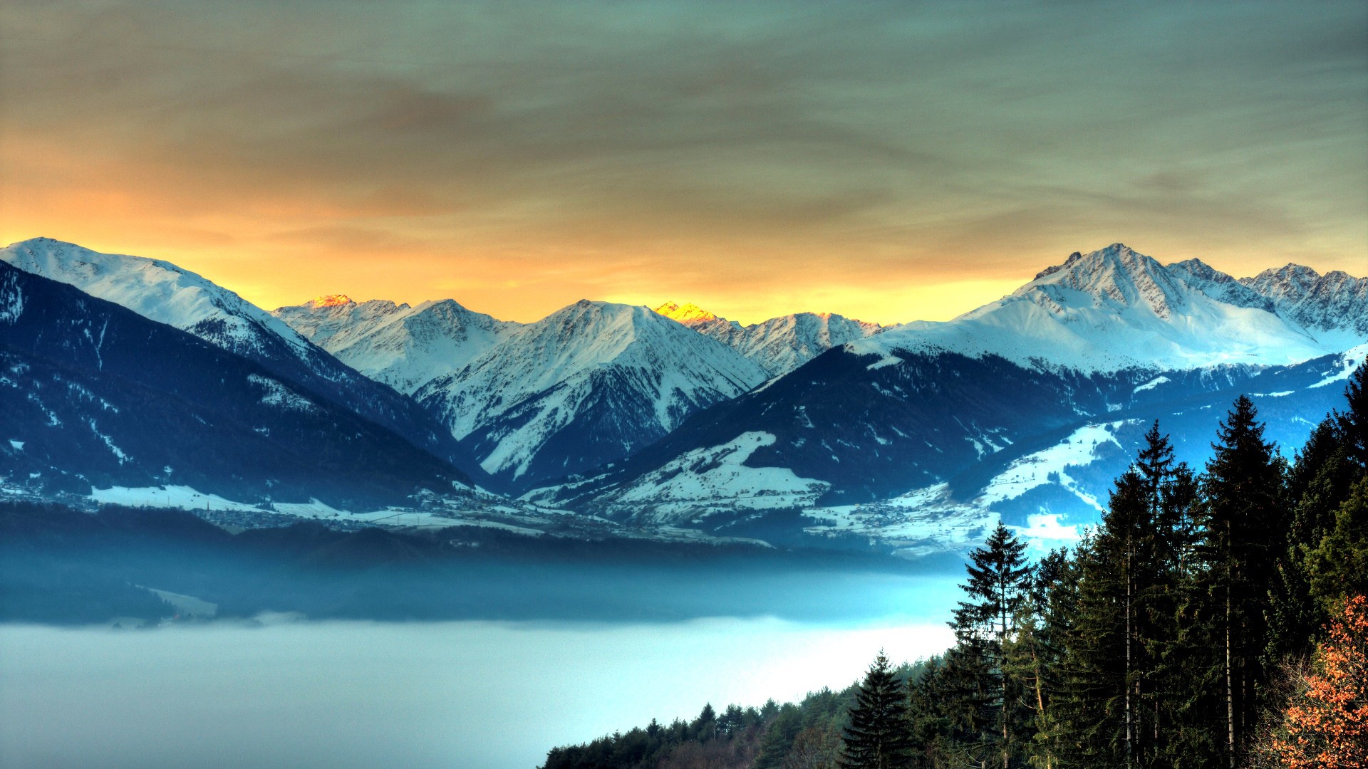
Mount Waddington (B.C) for Cordillera region because: shows its abstract peaks and mountain range. Shows glaciers and ice fields. Created by plate collision, pushing and folding mountains along with erosion.

Waterton Plains Alberta for Interior Plains because: shows the vast area of grassland yet with rolling hills and even though the plains are dry it shows some of the coniferous and mixed forest. Created from soils carried from the shield in rivers to layer upon one another.


Lake; Ontario for Canadian Shield because: shows it as flat bare rock and surrounded by water as erosion and weathering has brought it down to. not very populated. Weathering caused the once volcanic mountain range to diminish to flat areas.

Innuitian Mountain for Arctic region because: good example of fold mountains. Composed of sedimentary rock and covered in snow. The shield pushed rock thus forming the fold mountains.


St. Lawrence River for St. Lawrence lowlands because: very green flat fertile soil. Patches of orchards an farming with water source. When ice melted and then grew and froze once more it pushed the soil underneath causing the lowlands.


Appalachian Mountain region: shows the fjord and mineral deposits. Mountain and highlands. Sedimentary rock. Made by weathering and erosion of mountain ranges and glaciers.

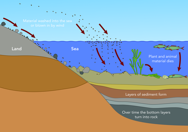
Topography Of Canada
Arctic Region: The Canadian Shield pushed sedimentary rock due to pressure thus creating Fold Mountains. It includes lowlands, plains, and mountains such as the Innuitian Mountains which cover the east part of the arctic. West is covered in lowlands. Due to global warming the ice has melted leaving mineral deposits.
(Selkirk Mou ntains)
Cordillera Region: Includes mountain ranges, trenches and valleys. It also holds, glaciers, ice fields and volcanoes that stretch on the mountain range from Alaska to Chile. It was formed when plates collides and earth’s crust felt apart. It holds mineral deposits; gold, copper, and coal. Rich fertile soil was the result of minerals carried downstream.
(Mount Waddington)
Interior Plains Region: Before the plains were what they are today, the area has a tropical climate. Water brought in carried plants and animals and over time they became embedded into the sedimentary layers, forming deposits of fossil fuels (natural gas, oil & evaporates eg. Potash) the plains were created as soils washed up at the brim of the Canadian Shield and soon began to build up. Flat with rolling hills, rivers and valleys. Flat grasslands were there before they evolved to boreal forest.
(Saskatoon prairie)

Canadian shield region: They are hard, rigid blocks, surrounded by younger continental land forms.This region once was a volcanic mountain range and over millions of years weathering and erosion have worn the land down to a landscape of flat, bare rock, lakes and wetlands. The shield is composed of many valuable minerals such as diamonds, gold and lead.
Stoney Lake, Ontario

The St. Lawrence Lowlands are between Lakes Huron, Erie, and Ontario, and extend along the banks of the St. Lawrence River to Quebec City.This region was formed by the retreating ice sheets that covered most of Canada. The ice sheets pushed soils from the Shield onto the area where the lowlands are today. The fertile land allowed First Nations people, such as the Huron, to practice a stable agricultural economy, and later European immigrants established farms and orchards. The St. Lawrence lowlands may be small but the are a home for almost half of Canada’s population because of the agriculture.
St. Lawrence River

The Appalachian region is an extension of the Appalachian mountains,which begin in the southeastern United States and end in the Maritime provinces of Canada. It has a varied landscape of rolling hills, valleys, small mountains, highlands, and coastal fjords. Lots of coal and minerals, fishing resources, big forests and farmland encouraged the creation of numerous communities along the coast and in the river valleys of the Appalachian region.
Rolling Hills, Nova Scotia

By: Essly & Jed

Five Themes of Geography
The five themes of geography include location, place, regions, movement, and human environmental interaction.
Location has two areas; absolute, meaning the exact location using coordinates. And relative, describing its location using landmarks or nearby cities. The landscapes of a region is known as place. Physical landscapes are natural occurrences of nature such as hills, mountains and rivers. Cultural landscapes are areas man made, like cities, nature parks and ponds.
Regions include; formal, which is a place that has an official boundary. Functional; areas preserved specifically for a certain activity; hospitals, scenery and museums. Perceptual regions are areas that people know but are not typed on the map. An example would be the dangerous parts of a city or in Vancouver downtown east Hastings. Movement and globalization go hand in hand with their theme of distribution of people, products information and trade. Human environmental interaction is the relationship we have with the environment we have around us and how we affect it. Here in Poco we take care of our environment by recycling our garbage and using public transportation.
To provide a more visual understanding it can be compared to Port Coquitlam. Absolute location of Port Coquitlam is 49.2625° N, 122.7811° W. Poco is relative to Coquitlam and Pitt meadows. Some of the physical landscapes of Poco is the Coquitlam River that runs alongside the downtown. There are many hills and a vast forest areas such as Colony Farm Regional Park. This regional park and many other parks lakes and areas are considered cultural landscape.
Poco is a formal region, due to its boundaries. The perceptual regions is North side and Southside that is not marked on a map but the community knows. Globalization occurs now through television or social networks along with companies and their marketing/merchandise. Environment is affected in Poco through land use and creating roads and constructing buildings. Also our carbon footprint.
The number 8747127
8747127
3x3x971903
8747127=3•3•971903
two factors=3
number of divisors=6
The Chrysalids-John Wyndham
Quickwrite Response #5
Aunt Harriet’s third child is a deviation to the social norm. It is never revealed what is wrong with the baby, but it must have been a minute flaw. Her last hope was to beg her sister (David’s mother) to switch children, before the inspector came to “clear” the child. However, in a previous chapter David, explains that his mother’s views align with his fathers, thus being strict about inspecting deviations. Aunt Harriet is rejected when she asks David’s mother. She obviously felt she had no other choice and without wanting to lose her third child, committed suicide. If I was in the same situation I think I would have collected my belongings including my baby, and run away and try to find someplace where I would be accepted. The entire system is screwed over the hatred towards flaws caused by the “devil”, so I don’t blame her for at least trying to hide her child.