February 26

Society in the 19th Century

Economy:

Society: Politics:
-Fishing

-Forestry

-Shipbuilding

-Clearing land to farm and build houses

-Barter economy

-Tenant farmers

-Fur trade (rural settings)

-farmers mortgaged their crops

-trade with Britain and US

-farming wasn’t always successful

-absentee landlord(land speculators)

-clergy reserves and government reserves tied up the lands

-less interaction because of distance between neighbours.

-closer knit community

-family background is important

-church is part of their routine

-quiet environment

-church is a part of their routine (meet with neighbours)

-religious holidays are when communities come together (music)

-clear class structure

-class boundaries are more

obscured in Canada vs Britain

-lower class want democracy

-lower class want democracy

-upper class is in power

-loyalty towards Britain

-tenant farmers


Farming


Pioneer homestead, Chatham, Upper Canada 1828 P.J. Bainbrigge

This image shows crops, simple log home from the cut trees in the back ground, and a farmer talking to who is presumed to be his land lord.

This is definitely a farm, that has crops, and it shows the presumed long distance between houses because he doesn’t look to have neighbours close by. The top hat on one of the persons of this image shows that he is an upper class person


Social Class

Picture11

North side of King, East of Toronto Street, 1829 (James Pattinson Cockburn)

Image shows 3 men in in coats and top hats and a kid in the same attire, a jail, a court house and a church, also lots of buildings on the right side with large amounts of people walking on the streets.

Looking at the men on the picture it looks like they are wearing formal and expensive clothing, the jail and courthouse and church shows that they live in a major city, and the large amounts of buildings tells us that lots of people visit or live in this city. By these characteristics it is safe to assume that this is an upper class city.


Religion
Picture10 

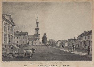
King St. E., looking e. from Toronto St., Young, Thomas, Year/Format: 1835, Picture

This is the same street and view like in the last picture but you can see some cows and citizens.

The large church can tell us that lots of people must go to church in this area.


Land Issues

Picture15

This paper shows reserved or bought land.

Upper class bought land they could farm or build homes on. The government and churches got lots of reserved land to work with too.


Loyalty to Britain
Picture9

Crown and Clergy Reserves, Newtown, Upper Canada, with one-seventh of the land held for clergy reserves, and oneseventh to produce government revenue, c. 1800. National Archives of Canada, NMC288

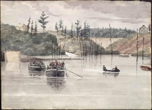
Jones Falls, Rideau Canal, Upper Canada. Artist: Bainbrigge, Philip John, 1817-1881. ca. 1838

Picture shows large boats with lots of people in it who are sporting red coats and oddly shaped hats. (Also not relevant to the topic, I think there’s a dam in the back ground.)

The people in the boats are loyalists, they were also called “red coats” at the time, I they were the soldiers who were loyal to Britain.

February 11

Global Warming and Settlement Patterns in Canada

Global Warming and Settlement Patterns in Canada.

Would it be a problem a problem for Canada if the climate warmed?

Yes, farms would dry out easier, there would be less vegetation, and Settlement Patterns would change drastically.

Assumptions on what factors affect settlement?

The latitude you live on, the climate you’re in, what kind of land you live on, flat or on a mountain side, precipitation.

How would it affect each physiographic if Canada’s climate warmed?

The Arctic Region is really cold, so I think the precipitation would change pretty bad, it would snow less and rain more. Which means more people would move there.

Cordillera Region, the coast is not really cold, and it rains a lot, that’s why lots of people live there, if the climate got warmer, it would rain less on the coast and rain more in the central part. Which means more people would live there.

The Interior Plains are generally cold. There bottom area is where most of the population lays.

I don’t think if the climate would get warmer that it people would make people spread out more.

Canadian Shield, it’s generally a warmer region, so if it got warmer people might spread to the coasts of the region. And rivers would dry up.

St. Lawrence Lowlands Region, lots of people live here, because it’s pretty warm, if it got any warmer people may spread north. The lowlands have open areas that would become dessert.

And finally the Appalachian Region, It’s warm here like the surrounding areas, and if the climate gets warmer, people would spread north. Soil will be less fertile, because it will be too warm for most plants.

February 7

Vegetation and Formation of Canada’s Physiographic Regions

The Arctic Region: Sub Arctic

These are the Ogilvie Mountains,in Yukon, it has a small valley and snow, which are results of being in the Sub Arctic ecosystem. Pressure from the north-eastern edge of the Canadian Shield pushed up the sedimentary rock to form a range of fold mountains.

Cordillera Region: Tundra, Open Woodland, Coniferous forest, Coast and Interior forest.

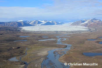
Tundra and large glacier on Bylot Island, Nunavut. I am aware that Nunavut isn’t part of the Cordillera region, but I thought this was a relevant enough picture. The Cordillera region is made up of lots of mountains that are separated by trenches, valleys and plateaus.

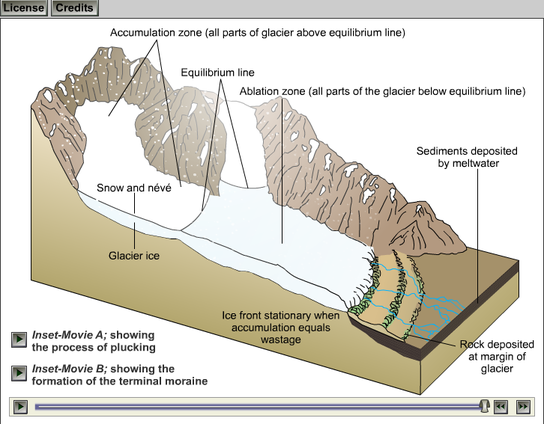
This diagram shows how valleys are made.

Interior Plains region: Tundra, Open Woodland, Coniferous forest, Parkland, Grassland.

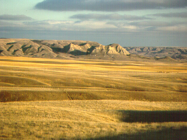
Alberta Southern Prairies, this picture shows lots of Grassland, which is also one of the ecosystems. The Interior plains are made up of soil that was carried down by rivers from the Canadian Shield and deposited at it’s edge. These soils became flat lands, river valleys and rolling hills.

Another diagram on how valleys are formed.

Canadian Shield region: Tundra, Open woodland, Coniferous forest, Mixed forest.

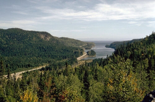
This picture was taken in Ontario, Canada. On this beautiful picture you can see rocks and Coniferous forest. The hard rigid rocks that take up half of Canada are often surrounded by younger continental landforms.

Coniferous Forests Diagram

St. Lawrence Lowlands region: Mixed forest.

Great Lakes, St. Lawrence. This picture contains lots of mixed trees, which indicates that it’s the Mixed forest. During the ice age, almost all of Canada was covered by ice sheets, these ice sheets retreated and pushed soils to make lowlands. When the ice sheets melted they made big lakes all over the St. Lawrence region.

This diagram shows how ice sheets retreat and deposit soil.

Appalachian Region: Open forest, Coniferous forest, Mixed forest.

Appalachian Mountains. As you can see on this picture, these mountains have lots of mixed forests.

The Appalachian region was an older range of mountains that was worn down by glaciers and by a million years of erosion, this made a varied landscape of rolling hills, valleys, small mountains, highlands, and coastal fjords.

February 4

Physical Regions of Canada

There are six Topographic regions in Canada. Topography is about the landscape of a certain region.                                The six regions are; Arctic Region, Cordillera Region, Interior Plains Region, Canadian Shield Region, St. Lawrence Lowlands Region and Appalachian Region.

The Arctic Region contains plains, lowlands, and mountains, it also contains a range of fold mountains.

 This is Devon Island in Nunavut, this Island is located in The Arctic Region.


The Cordillera Region has lots of parallel mountain ranges that are separated by plateaus, trenches, an valleys in the province of British Columbia.


IMAG1450 (2)

This picture was taken by me in Lillooet, it is a really large and long valley.


The Canadian Interior Plains Stretch from the Canadian Shield to the Cordillera mountains. The Interior Plains contain flat spaces, grasslands and rolling hills. 

I don’t exactly know where this picture was taken, but I think it is really cool, because you can see a really flat land and rolling hills the background.


The Canadian Shield Region is full of rocks, and that’s where it got it’s name, because there’s rock everywhere in this region.

This picture was taken in Northwestern Ontario at  Perrault Falls.
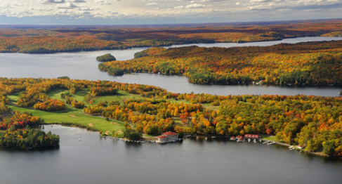


The St. Lawrence Lowlands where made by retreated ice sheets that covered most of Canada during the ice age. Soils from the Canadian Shield were pushed to where the lowlands are today. And the ice sheets that melted became lakes.

The lakes on this picture are located in Muskoka, Ontario.
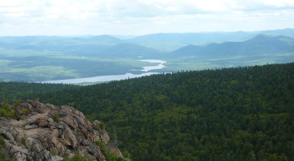


The Appalachian Region consists of coastal fjords, highlands, small mountains, rolling hills and valleys.

 This picture of small mountains and a valley was taken near  Saint John, New Brunswick.


And this concludes the Physical Regions of Canada.  Post made by: Botond Diosy. (I didn’t have a partner on this.)

February 3

The 5 Themes of Geography

The Five Themes of Geography, are five categories where different kinds of geography belong.

The first theme is; Location, Absolute and Relative locations: Absolute location is an exact location, marked by coordinates, legal address, civic address or other methods. Example; The coordinates of Port Coquitlam are “49.2625° N, 122.7811° W”, which is an absolute location. Relative location; A location or orientation only used by a certain relevant group.  Example; “West Port Coquitlam”.

Another Theme of Geography is; Place. Place has 2 categories, Physical Landscape and Cultural Landscape. A Physical Landscape applies to the features of a certain location. Example; The forest by Gates Park.                                  A Cultural Landscape, the visible results of human activity. Example; Gates Park, big open fields.

The third theme of Geography is Regions; Formal, Functional and Perceptual regions. Formal regions are based on official boundaries, like cities and provinces. Example; Port Coquitlam, BC, Canada.                                                             A Functional region is based on connections created by an activity such as communication. Example; The area that the Tri City Newspaper is distributed in.                                                                                                                                             And a Perceptual Region is determined by the peoples attitudes and feelings. Example; The boundaries on a open field that has no markings.

The fourth theme is Movement; Globalization: The process of economic, technological, political and cultural combining and creating a single global society. 

Human and Environmental Interaction, is the fifth and final Theme of Geography. In this category exists “Human interaction with the environment”; How people adapt to a certain environment. Example; How our trash containers, cans and dumbsters have bear safe locks on them.

And that concludes The Five Themes of Geography.